METRO MANILA’S location naturally exposes it to numerous risks. The region is sandwiched between the Manila Bay to the west and Laguna de Bay to the east. Located in a Pacific country, the metropolis is a hotspot for devastating typhoons. It also sits on top of the West Valley Fault and is near the Manila Bay Fault and the Manila Trench. It is at a constant risk of a catastrophic earthquake.
Another danger lies in the government’s failure to impose existing infrastructure laws. In a paper entitled “Vulnerability, Adaptation, and Resilience to Floods and Climate Change-Related Risks among Marginal, Riverine Communities in Metro Manila,” Sociology and Anthropology Department Chair Emma Porio, PhD, notes that “the ability of government agencies to impose building and infrastructure standards is quite weak.”
Climate change has become a serious concern for the city. According to the Metropolitan Manila Development Authority (MMDA), Metro Manila is now the “third most vulnerable to climate change” among Southeast Asia’s districts and provinces.
Urban diaspora
Despite these, people from all over the country have migrated to Metro Manila, mainly in search of greener pastures. In Porio’s tracing of the city’s population explosion, she reports that Metro Manila’s population “expanded from 5.93 million in 1980 to 7.95 million in 1990, 9.93 million in 2000 and is projected to reach 19.43 million in 2020.” Even if the region has 12 million residents, its population is estimated to balloon to 16 million during the daytime, counting those who come to work from nearby provinces.
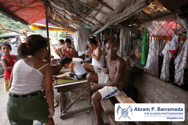
Insufficient housing for these urban immigrants has paved the way for the rise of informal settlements. These communities, Porio writes, are “located in or near danger zones” and are lacking in basic “services like water, electricity, health and substandard roads, drainage, and sewage systems.”
The metropolis’ population density is the highest in the country, with 19,317 people per square kilometer, according to the 2010 census of the National Statistics Office. Manila itself is considered to be the world’s most densely populated city, with 43,079 people cramped per square kilometer.
Manila grand plans
Poor urban planning has always been blamed for the city’s misfortunes. Evidence of this lies in the its lack of green spaces crucial for maintaining its ecological balance and the prevalence of slum colonies—a lot of which have already clogged the esteros (streams) or waterways that are supposed to help in preventing floods and even spur trade and tourism.
Before, Manila’s esteros were not something to be ashamed of. In 1905, American architect and urban planner Daniel Burnham, responsible for developing the master plans for downtown Washington, DC and Chicago in the United States and Baguio in central Luzon, envisioned a grand plan for the Philippine capital.
Burnham knew that the city of a hundred thousand would one day be a city of a million and more. He intended Manila to become a city full of grand monuments with green spaces. However, it was Burnham’s plan for the esteros that drew greater attention. Though unattractive, he saw these waterways as essential for the city’s trade, since they were then an important means of transportation. He believed that “[the esteros] can become, as in Venice, an element of beauty.”
However, much of these plans were scrapped for other projects.
Broken government
The government’s failure to execute plans for a carefully planned-out capital has apparently taken its toll on the government itself.
Former president Manuel Quezon also had dreams of a grand capital. The plan for a new capital city north of Manila was also approved in 1941. Drawing inspiration from New York’s Central Park, the plan was for Quezon City to have a 400-hectare green space at its very heart. The three branches of government would finally be in one huge elliptical site. The new Congress building would be at the middle of the ellipse, while the new Presidential and Supreme Court buildings would be built at the ellipse’s two ends.
Today, the House of Representatives is up north in Quezon City, while the Senate holds sessions down south in a rented space at the Government Service Insurance System building in the reclamation area in Pasay City. In between, the president and the justices of the Supreme Court have their offices in Manila. These differences in location have posed accessibility problems and have become a hindrance for efficient governance.
Decongesting, relocating
Some think that Metro Manila is a hopeless case, and that it is time to move out. In an article published in the Manila Bulletin last July 10, MMDA Chair Francis Tolentino said that it is “high time we consider the possibility of developing other areas beyond the metropolis, and build a new capital city there, just like other countries in the world.”
The government is now aggressively looking for ways to develop other areas outside Metro Manila. Cecilio Ortiz, a project director at the Civil Aviation Authority of the Philippines, says, “Modern infrastructure…vwill spread development into the countryside and other growth centers… providing more opportunities outside the metropolis, hence decongesting Metro Manila.”
Saving the Pearl of the Orient
It is quite clear that the populace and the government should make sure that calamitous events and their effects are minimized. Recently, there have been efforts such as the recently approved P351 billion flood control system that will be in place come 2035. Certainly a long-term fixture, it is a move that shows the government’s foresight and patience.
Porio says that more than urban planning, it is the change in people’s behavior that would help the city get back on its feet. Indeed, simple acts such as throwing trash in the proper place will go a long way in saving the environment.
Lamenting the zoning exemption issued by the Quezon City Council to the SM Blue Residences, a high-rise condominium beside the Ateneo and just a short distance from the West Valley fault line, she stresses that the government should enforce laws that will guarantee the safety of the people.
What will allow the Pearl of the Orient to continue shining through are its citizens’ small deeds, along with a bit of wise prescience.


