AS METRO Manila is met with explosive urbanization, the gap between city development and the integration of local climate science data grows wider. While interest in hyperlocal environmental data—from risk mapping to air quality indices—is growing, urban development often moves ahead without it.
This disconnect exacerbates disaster vulnerability, underscoring the need to build safer and more resilient cities by understanding changing climate and weather conditions with guidance from climate centers like the Manila Observatory (MO).
Tracking volatilities
MO is one of the few climate monitoring centers in the country, complementing the work of the Philippine Atmospheric, Geophysical, and Astronomical Services Administration, the Philippine Space Agency, and its own policy and communication arm, the KLIMA Center.
Headquartered in the Loyola Heights campus as a Jesuit scientific apostolate, the Observatory has automated weather stations (AWS) set up across the country, generating localized weather data in Luzon, Visayas, and Mindanao. These parameters include rainfall, wind direction, sunlight, and air quality.
Data gathered by MO is translated into accessible resources, such as the High-Definition Clean Energy Climate and Weather Forecast, which provides a five-day forecast for the Philippines, and Panahon, a website that uses simulations and timely monitoring tools for atmospheric research.
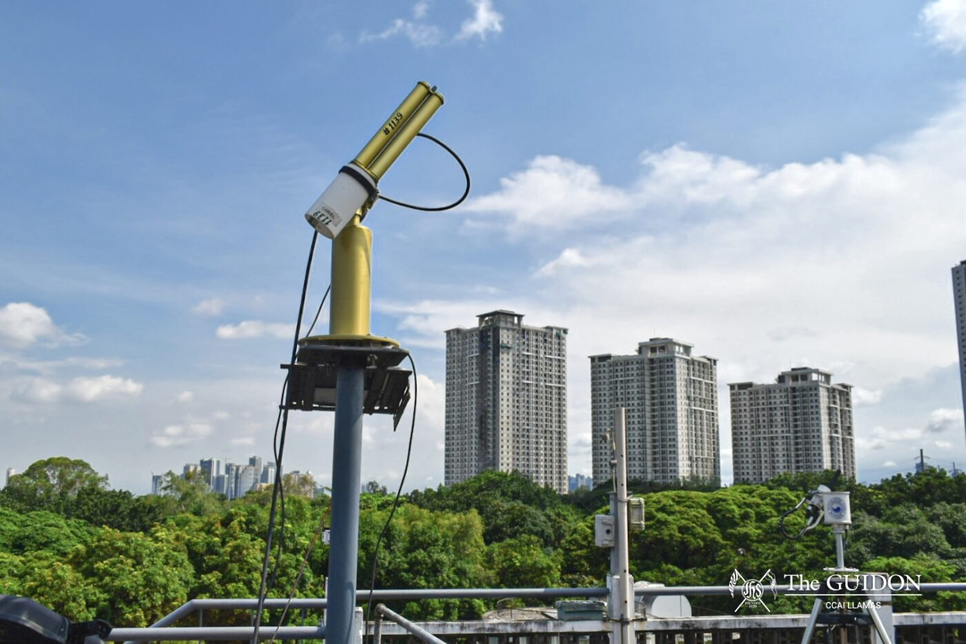
Alongside these platforms, MO also houses the Aerosol Robotic Network (AERONET), which is part of a global network of sun and aerosol photometers tasked to capture the movement of the sun throughout the day.
These services are augmented by the Observatory’s location for the last 60 years in a relatively elevated part of Metro Manila, overlooking Marikina Valley and the plains of Quezon City. According to MO Geodynamics Research Laboratory Research Assistant Randell Teodoro, this site has provided a prime space for weather forecasting and atmospheric studies since MO’s relocation to Loyola Heights from its post-war operations in Baguio.
However, as populations grow and economic activity rises, cities demand more housing, roads, and employment, birthing tall concrete structures all over the Metro. In Katipunan, high-rise condominiums less than 20 years old now cut AERONET’s 360-degree line of sight and disrupt AWS monitoring.
Science among skyscrapers
In the earlier days of the Observatory, Teodoro shared that surrounding trees could still be trimmed so instruments like AERONET could access a wider line of sight. However, the same adjustments cannot be made for the concrete towers embedded in the country’s current urban system.
“Well, it’s a compromise—you want to be in the center of the city […] but at the same time, you get a problem of restrictions in the surrounding areas,” Teodoro asserted.
Likewise, one of the climate scientists of MO’s Regional Climate Systems Laboratory, Lyndon Olaguera, PhD, confirmed that these long-term stations previously established in rural areas now face challenges from urban sprawl. “The main issue is that the site’s reading no longer represents regional climate trends because they start reflecting a heavily altered artificial microclimate,” he emphasized.
Expounding on this, he argued that AWS readings are now being altered by signal contamination and surface energy balance disruption, even if global climate change has not necessarily shifted local occurrences.
Signal contamination is the interference of ambient, incidental factors with measured data or the signal received by an instrument. As tall buildings block airflow, signal contamination manifests in inconsistent wind speed measurements.
Besides this, Olaguera added that the urban heat island effect, which makes cities feel hotter than their surrounding rural areas, increases local temperatures. This creates ambiguity between long-term global warming and local land use effects. Local precipitation records are also disrupted by aerosols and pollutants, affecting cloud formation.
Meanwhile, surface energy balance refers to the exchange of energy between surfaces and the atmosphere through conduction and convection, which materials like concrete and asphalt disrupt by retaining heat. According to Olaguera, urban developments that introduce these materials end up altering the albedo, emissivity, and heat flux in physical processes, and in turn interfere with temperature, humidity, and wind measurements.
Alongside these complications, Olaguera explained that the spatial coverage of climate and atmospheric data outside Manila remains sparse, with significant limitations in other urbanized metropolitan areas across the country.
“In Metro Manila, we have 40 [AWS]. But in other cities, like Iloilo [and Cagayan de Oro], the AWS of Manila Observatory is only around two [AWS each]. […] In Davao, I think there is only one [AWS] operational,” he discussed.
Beyond atmospheric data, Teodoro highlighted that urbanization also affects geologic monitoring of stations outside Metro Manila. For example, the city of Davao hosts a seismometer monitored by MO, given the city’s vulnerability to seismic and volcanic activity along the Ring of Fire.
“The station is near a road, so if large trucks pass by, our seismometers are able to pick it up. The effect of urbanization on scientific research and seismology is that you get more noise because of foot traffic, even the interior traffic,” Teodoro shared.
These challenges underscore the importance of integrating localized climate data into urban planning to guide decisions on land use, development densities, and infrastructure. By doing so, public spaces, street layouts, and building orientations can be optimized with wind flow patterns and solar access data, reducing energy consumption and improving natural ventilation.
Responding to uncertainty
Despite the seemingly anachronistic state of climate research in an urbanized world, Teodoro noted that institutes are adapting to these changes by expanding station networks and comparing data values accordingly. He adds that combining station data with measurements from satellites or portable, in-situ instruments can also remedy the limitations caused by urban interferences.
Similarly, Olaguera shared that the Observatory has been actively adjusting the location of its weather stations to less crowded areas or on top of buildings to minimize the effect of signal contamination. He adds that these measures protect and ensure the integrity of climate data, shaping more adaptive cities through evidence-based decision-making.
Olaguera further explained that planners and policymakers must blend climate work into long-term and day-to-day operations. “The presence of climate information or weather information improves the credibility of decisions,” he mentioned.
With climate data, Olaguera pointed out that real-time monitoring of rainfall, wind, and sea level changes can be integrated into an early warning system. He also stressed the need to map vulnerable areas like low-lying barangays and heat-prone urban cities to enable more proactive community and government responses.
“Future readiness hinges not only on better data, but also on more localized modeling, stronger observational networks, open data access, and capacity building, so that science translates into practical [and] equitable adaptation measures,” he advised.
Ultimately, in facilitating intentional policymaking and planning amid rapid urbanization, climate centers are both integral to and impacted by an increasingly complex world. As such, climate data and networks must be reliable and agile for disaster resilience mitigation and adaptation strategies.
ERRATUM: Lyndon Olaguera, PhD, is a member and climate scientist of the Manila Observatory’s Regional Climate Systems Laboratory. The article has been edited to reflect these changes. We apologize for the oversight.