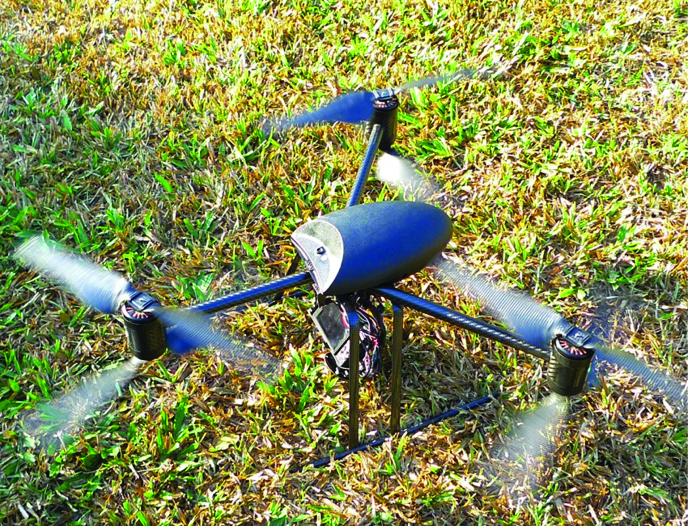
MAKING HEADWAY in aerial imaging, the Ateneo Innovation Center’s (AIC) project-turned-company, SkyEye, built unmanned aerial vehicles (UAVs) for retrieving images of the earth’s surface.
AIC member and SkyEye board member Nathaniel Libatique, PhD headed this project entitled “Design and Development of Aerial Mapping and Imaging Systems and Standards.” Libatique is also an associate professor from the Electronics, Computer and Communications Engineering (ECCE) Department.
Flying 300 meters above the ground, the UAVs, also known as drones, take high-resolution images with the use of commercial cameras to make aerial images.
SkyEye adds metadata on top of the images, which provide clients with information about the land area covered in the image. For example, an image may contain metadata on the identity of the land owner, the status of a fish cage in the area or even the presence of the shoreline before or after an earthquake.
The UAVs are employed in the evaluation of the integrity of infrastructures, especially areas affected by natural disasters. These are used in precision agriculture for better management of lands and crops and in disaster management research.
The Philippine Council for Industry, Energy and Emerging Technology Research and Development and the Commission on Higher Education are currently financing the project.
From the outset
The company started as a business idea of management with applied chemistry major Matthew Cua, which he presented in the Innovation and Technology class of ECCE Professor Gregory Tangonan, PhD. Tangonan is currently the SkyEye director.
In this class, Cua reported on multi-rotor helicopters and its use in aerial imaging. Tangonan said that, to Cua’s credit, he was heavily engrossed in the idea and wanted to buy a helicopter to develop it.
Several faculty members and students became interested as well and they decided to develop software for the helicopter.
This then developed into the AIC’s SkyEye, with Cua as the project’s chief executive officer.
Tangonan shared how people abroad were surprised upon discovering that the Philippines is now able to take world-class aerial images.
According to Tangonan, “Innovation can come from anywhere.”
Making progress
SkyEye has already deployed UAVs for a number of missions.
The SkyEye team was able to survey the outcome of the 2013 Bohol earthquake. The UAV also helped the Quick Response Team of the Philippine Institute of Volcanology and Seismology with the aerial mapping of the recently uncovered fault line in Bohol.
According to Tangonan, there are government agencies, such as the Department of Environment and Natural Resources, which have been coordinating with SkyEye. The UAVs have been used to survey forests and to mitigate illegal logging activities.
“You can really help the country develop its plans and execute its plans [with our UAVs],” Tangonan said.
SkyEye has deployed its UAVs in 28 other missions to take aerial mappings of the following: A fish pen area that may affect the waters of Lake Palakpakin, San Pablo City, Laguna, the waters of the Aklan River, Panay Island to be used for research on topography, the lands in Javier, Leyte to be used for surveillance of infrastructure and changes in usage of terrains, among others.
Potential
According to Tangonan, the scientific community should start utilizing aerial imaging and conducting long-term research about it.
He said that SkyEye plans to invite experts and specialists to develop new uses for aerial images that are in line with what these professionals need in their respective fields.
Moreover, aerial imaging will allow SkyEye to study the long-term effects of several disasters in an area and how this affects land usage.
Tangonan said SkyEye also plans to conduct research on ways to cope with climate change.
With the many promising areas of potential use for aerial imaging, Tangonan believes that SkyEye will be in this business “for quite a while.”
Dodging risks
Several students find the project to be particularly useful in disaster risk management.
Computer Society of the Ateneo President Patrick Chua believes that the project is a cost-efficient manner of gathering data in assessing which areas are susceptive to natural disasters.
While he remains optimistic that the project may lead to a relatively safer Philippines in the long-term, he said that “data is just data.”
“It is what we do with the data that will matter the most,” Chua said.
Meanwhile, electronics and communications engineering freshman Pauline Santos believes that surveying the damage of affected areas may aid in the assessment of what may be done given the apparent extents of the damage.
In the case of relief efforts, Santos said that the data from the UAVs may “help conduct research or assess how much help in relief may be needed in an area, as well as mapping routes logistically to get the relief to the affected.”